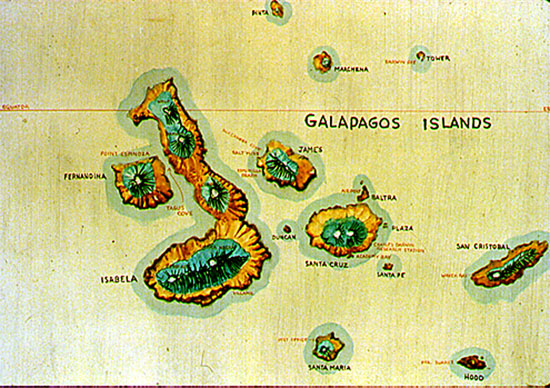
 The Galápagos Islands, also known as the Islas Encantadas, lie
approximately 1000 km (600 mi) west of Ecuador, straddling the equator. The
archipelago consists of 13 major islands, 6 small islands, and scores of islets
and rocks, with a total land area of 7882 sq km. As suggested in the drawing,
the islands are of volcanic origin. In fact, the westernmost major island,
Fernandina, and the largest island, Isabela, are sites of frequent eruptive
activity.
The major islands are shield volcanoes, immense piles of basaltic lava
flows built up off the sea floor. Shield
volcanoes ideally have a very broad, gently convex upwards profile, such
as a Viking's shield laid flat on the ground might exhibit. Santa Cruz island, in the background, shows the
classic shield volcano profile. The island of Fernandina shows a variation
on this profile, where the volcano, historically the most active, has built up
a somewhat steeper-sided pile in the middle
of the otherwise low-profile island. The cactus in the foreground belongs to
the genus Brachycereus; this cactus is one of the early colonizers of
new lava terranes. Sometimes the cactus is engulfed by later flows, as shown
by molds of Brachycereus preserved in some flows.
Many of the giant shield volcanoes feature an impressive caldera at
their summits. The largest is the caldera
of Volcán Sierra Negra. This immense
oval depression is about 10 km long, and floored with lava flows. Calderas
differ from ordinary volcanic craters in that they are not merely the vent
through which volcanic products issue. Calderas result from collapse of the
surface of the volcano caused by the withdrawal of vertical support when large
scale eruptions take place.
Not all eruptions take place from summit vents. Flank eruptions may
occur, especially in larger volcanoes where the pressure needed to raise the
magma to the summit may exceed that needed to cause it to burst through lower
on the flank of the pile. The main volcanic pile of Fernandina is dotted with
little parasitic cones showing where flank
eruptions have occurred.
These shield volcanoes are produced at thermal features known to geologists as
"hot spots". Hot spots are areas on the earth's surface characterized
by unusually high heat flow, commonly manifested in volcanic activity. The hot
spots are believed to overlie mantle plumes, slowly rising columns,
perhaps 150 km in diameter, of hot, viscous mantle material. The rising mantle
plumes spread out radially beneath the tectonic plates, heating the overlying
lithosphere. Volcanoes may form on the surface of the overlying lithospheric
plate, only to be carried away from the heat source by plate movement. For an
in-depth discussion of the concept of hot spots and mantle plumes, see Morgan
(1972).
The Hawaiian Islands are the classic example of a linear string of shield
volcanoes formed at a hot spot over a mantle plume; the young, active
volcanoes are at the southeast end of the Hawaiian volcanic chain, with
inactive and increasingly older and more eroded volcanoes strung out to the
northwest from the hot spot. Similarly, the Galápagos Islands are
shield volcanoes formed over a hot spot, with the youngest and most active
volcanoes at the west end of the chain. Plate movement is to the
east-southeast, on a bearing of 102 degrees (Hey, et al., 1977).
Volcanic activity in the Galápagos generally diminishes eastward from
Isabela; however activity has been more widespread and less linear than in the
case of the Hawaiian Islands hot spot chain. Eruptions have occurred in
historic times on Santiago, Marchena, Pinta and Santa María. Although
parts of the Santa Cruz shield are more than a million years old, it is still
considered an active volcano. Even San Cristóbal, at two and a half
million years old and the easternmost of the major islands, is considered still
active. But Española, the southeasternmost island is extinct and
eroded.
When a volcano becomes extinct, the forces of erosion take over and the cone
is eventually destroyed. At Punta Suárez, on Española, the
wave-eroded cliffs reveal stacked lava flows
that make up the internal structure of a shield volcano. The white color is
due to the droppings of countless sea birds; Punta Suárez is a world
class sea bird rookery, with waved albatrosses, swallow-tailed gulls, and
thousands of blue-footed and masked boobies. Behind the cliffs the surface
rises in the gentle slopes typical of a shield volcano.
Underwater to the east of the Galápagos archipelago lies the Carnegie
Ridge, also a product of the Galápagos hot spot. This volcanic ridge
is dotted with sea mounts, one of which has been dated at eight million years
old. This sea mount shows evidence of having once been a volcanic island, now
sunk to a depth of 1500 m as plate movement has carried it away from the
uplifted area of the hot spot proper.
The Galápagos hot spot lies, at present, just south of the crest of
the Cocos-Nazca spreading ridge, and there is good reason to believe that
sea-floor spreading has had a significant effect on the formation of the
archipelago. The complex relationship between the Galápagos hot spot
and sea-floor spreading at the Cocos-Nazca ridge is described by Hey (1977) and
Hey et al. (1977).
A pattern of normal faults can be seen in this air view of North Seymour and Baltra islands. North Seymour (left)
is separated by a straight, fault-bounded channel from Baltra Island (right)
where the main airport lies. Baltra itself is cut by several faults, and the
Baltra harbor results from down-dropping of one of these fault blocks. Another
channel, probably also fault-bounded,
separates Baltra from the larger island of Santa Cruz. These normal faults
trend roughly east-west, generally parallel to the Cocos-Nazca spreading ridge
to the north, and may be the result of regional north-south stretching related
to sea-floor spreading. Alternatively, they possibly result from more
localized doming and stretching of the surface of the Santa Cruz shield
volcano.
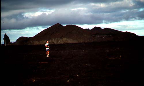
In addition to the large shield volcanoes, the Galápagos islands feature
nearly countless smaller cones and volcanic structures, such as these dotting
Santiago Island in this famous view from
the small cone that forms Bartolomé Island. Sombrero Chino (Spanish, "Chinese Hat") is a small island formed by
a single extinct cone, as is the smaller Daphne Major, whose crater floor is the nesting ground for a colony
of blue-footed boobies. Even smaller craters form rings just at sea-level at the base of the main cone of
Bartolomé; the red specks in the upper right of the photo are tourists
at the boat landing.
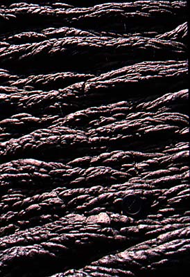
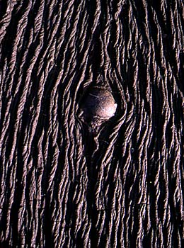
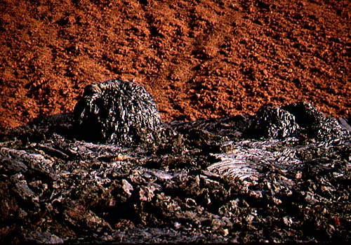
Interesting structures found on the flanks of some of the volcanoes are lava
tubes. The tubes, or tunnels, are formed when the exterior of a lava flow
cools enough to solidify over a still flowing, molten interior. If the molten
lava finds a way to flow out the downstream end, the tube may drain, leaving
behind an open tunnel of lava rock. One such lava
tube on Santa Cruz island is a commonly visited tourist site. The tube is
entered through a portion of collapsed roof, and lit by a natural skylight formed by a smaller collapse. On the walls of the
tube are horizontal lines parallel to the flow
direction, perhaps marking receding lava levels. Lava tubes come in
various sizes, not all big enough to walk in.
That the Galápagos are an area of tectonic activity is shown in ways
other than young fault scarps and active volcanoes. At Punta Espinoza on
Fernandina Island, tectonic uplift has rendered a dock (background, right center) inaccessible to the tour boats it
was built to serve. At Urbina Bay, on Isabela Island, giant coral heads lie bleached and dead after being suddenly
uplifted out of the sea in 1954, apparently during an earthquake event.
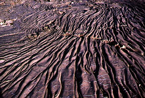
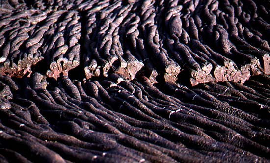
Although Fernandina and Isabela are the most volcanically active islands,
an eruption on the island of Santiago around the turn of the century produced
a major flow that spread down to the sea,
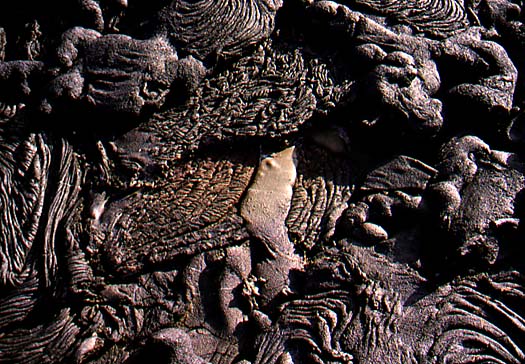
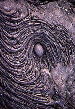
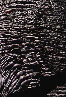
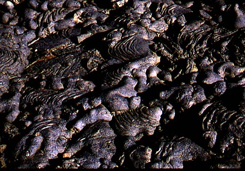
creating new land and forming what is surely the most spectacular pahoehoe flow
easily accessible by visitors to the Galápagos. A two kilometer trail
at Sullivan Bay provides amazing views of the fresh, unweathered pahoehoe lava
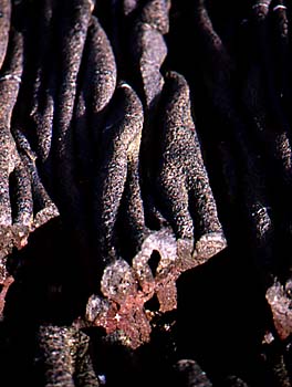
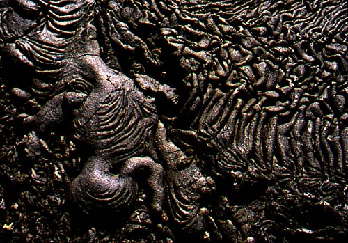
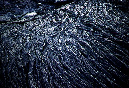
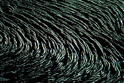
looking much as if it were still in motion, rippling, seething and bubbling. The click-on entries below will
bring up photos taken on a short walk across the surface of the flow. It is a
classic example of pahoehoe lava, featuring many truly beautiful, grotesque
and fascinating surface forms. It is hard to stop taking pictures...
SULLIVAN BAY FLOW PHOTO GALLERY: Motion Frozen in Stone
The Galápagos Islands, also known as the Islas Encantadas, lie
approximately 1000 km (600 mi) west of Ecuador, straddling the equator. The
archipelago consists of 13 major islands, 6 small islands, and scores of islets
and rocks, with a total land area of 7882 sq km. As suggested in the drawing,
the islands are of volcanic origin. In fact, the westernmost major island,
Fernandina, and the largest island, Isabela, are sites of frequent eruptive
activity.
The major islands are shield volcanoes, immense piles of basaltic lava
flows built up off the sea floor. Shield
volcanoes ideally have a very broad, gently convex upwards profile, such
as a Viking's shield laid flat on the ground might exhibit. Santa Cruz island, in the background, shows the
classic shield volcano profile. The island of Fernandina shows a variation
on this profile, where the volcano, historically the most active, has built up
a somewhat steeper-sided pile in the middle
of the otherwise low-profile island. The cactus in the foreground belongs to
the genus Brachycereus; this cactus is one of the early colonizers of
new lava terranes. Sometimes the cactus is engulfed by later flows, as shown
by molds of Brachycereus preserved in some flows.
Many of the giant shield volcanoes feature an impressive caldera at
their summits. The largest is the caldera
of Volcán Sierra Negra. This immense
oval depression is about 10 km long, and floored with lava flows. Calderas
differ from ordinary volcanic craters in that they are not merely the vent
through which volcanic products issue. Calderas result from collapse of the
surface of the volcano caused by the withdrawal of vertical support when large
scale eruptions take place.
Not all eruptions take place from summit vents. Flank eruptions may
occur, especially in larger volcanoes where the pressure needed to raise the
magma to the summit may exceed that needed to cause it to burst through lower
on the flank of the pile. The main volcanic pile of Fernandina is dotted with
little parasitic cones showing where flank
eruptions have occurred.
These shield volcanoes are produced at thermal features known to geologists as
"hot spots". Hot spots are areas on the earth's surface characterized
by unusually high heat flow, commonly manifested in volcanic activity. The hot
spots are believed to overlie mantle plumes, slowly rising columns,
perhaps 150 km in diameter, of hot, viscous mantle material. The rising mantle
plumes spread out radially beneath the tectonic plates, heating the overlying
lithosphere. Volcanoes may form on the surface of the overlying lithospheric
plate, only to be carried away from the heat source by plate movement. For an
in-depth discussion of the concept of hot spots and mantle plumes, see Morgan
(1972).
The Hawaiian Islands are the classic example of a linear string of shield
volcanoes formed at a hot spot over a mantle plume; the young, active
volcanoes are at the southeast end of the Hawaiian volcanic chain, with
inactive and increasingly older and more eroded volcanoes strung out to the
northwest from the hot spot. Similarly, the Galápagos Islands are
shield volcanoes formed over a hot spot, with the youngest and most active
volcanoes at the west end of the chain. Plate movement is to the
east-southeast, on a bearing of 102 degrees (Hey, et al., 1977).
Volcanic activity in the Galápagos generally diminishes eastward from
Isabela; however activity has been more widespread and less linear than in the
case of the Hawaiian Islands hot spot chain. Eruptions have occurred in
historic times on Santiago, Marchena, Pinta and Santa María. Although
parts of the Santa Cruz shield are more than a million years old, it is still
considered an active volcano. Even San Cristóbal, at two and a half
million years old and the easternmost of the major islands, is considered still
active. But Española, the southeasternmost island is extinct and
eroded.
When a volcano becomes extinct, the forces of erosion take over and the cone
is eventually destroyed. At Punta Suárez, on Española, the
wave-eroded cliffs reveal stacked lava flows
that make up the internal structure of a shield volcano. The white color is
due to the droppings of countless sea birds; Punta Suárez is a world
class sea bird rookery, with waved albatrosses, swallow-tailed gulls, and
thousands of blue-footed and masked boobies. Behind the cliffs the surface
rises in the gentle slopes typical of a shield volcano.
Underwater to the east of the Galápagos archipelago lies the Carnegie
Ridge, also a product of the Galápagos hot spot. This volcanic ridge
is dotted with sea mounts, one of which has been dated at eight million years
old. This sea mount shows evidence of having once been a volcanic island, now
sunk to a depth of 1500 m as plate movement has carried it away from the
uplifted area of the hot spot proper.
The Galápagos hot spot lies, at present, just south of the crest of
the Cocos-Nazca spreading ridge, and there is good reason to believe that
sea-floor spreading has had a significant effect on the formation of the
archipelago. The complex relationship between the Galápagos hot spot
and sea-floor spreading at the Cocos-Nazca ridge is described by Hey (1977) and
Hey et al. (1977).
A pattern of normal faults can be seen in this air view of North Seymour and Baltra islands. North Seymour (left)
is separated by a straight, fault-bounded channel from Baltra Island (right)
where the main airport lies. Baltra itself is cut by several faults, and the
Baltra harbor results from down-dropping of one of these fault blocks. Another
channel, probably also fault-bounded,
separates Baltra from the larger island of Santa Cruz. These normal faults
trend roughly east-west, generally parallel to the Cocos-Nazca spreading ridge
to the north, and may be the result of regional north-south stretching related
to sea-floor spreading. Alternatively, they possibly result from more
localized doming and stretching of the surface of the Santa Cruz shield
volcano.
In addition to the large shield volcanoes, the Galápagos islands feature
nearly countless smaller cones and volcanic structures, such as these dotting
Santiago Island in this famous view from
the small cone that forms Bartolomé Island. Sombrero Chino (Spanish, "Chinese Hat") is a small island formed by
a single extinct cone, as is the smaller Daphne Major, whose crater floor is the nesting ground for a colony
of blue-footed boobies. Even smaller craters form rings just at sea-level at the base of the main cone of
Bartolomé; the red specks in the upper right of the photo are tourists
at the boat landing.
Interesting structures found on the flanks of some of the volcanoes are lava
tubes. The tubes, or tunnels, are formed when the exterior of a lava flow
cools enough to solidify over a still flowing, molten interior. If the molten
lava finds a way to flow out the downstream end, the tube may drain, leaving
behind an open tunnel of lava rock. One such lava
tube on Santa Cruz island is a commonly visited tourist site. The tube is
entered through a portion of collapsed roof, and lit by a natural skylight formed by a smaller collapse. On the walls of the
tube are horizontal lines parallel to the flow
direction, perhaps marking receding lava levels. Lava tubes come in
various sizes, not all big enough to walk in.
That the Galápagos are an area of tectonic activity is shown in ways
other than young fault scarps and active volcanoes. At Punta Espinoza on
Fernandina Island, tectonic uplift has rendered a dock (background, right center) inaccessible to the tour boats it
was built to serve. At Urbina Bay, on Isabela Island, giant coral heads lie bleached and dead after being suddenly
uplifted out of the sea in 1954, apparently during an earthquake event.
Although Fernandina and Isabela are the most volcanically active islands,
an eruption on the island of Santiago around the turn of the century produced
a major flow that spread down to the sea,
creating new land and forming what is surely the most spectacular pahoehoe flow
easily accessible by visitors to the Galápagos. A two kilometer trail
at Sullivan Bay provides amazing views of the fresh, unweathered pahoehoe lava
looking much as if it were still in motion, rippling, seething and bubbling. The click-on entries below will
bring up photos taken on a short walk across the surface of the flow. It is a
classic example of pahoehoe lava, featuring many truly beautiful, grotesque
and fascinating surface forms. It is hard to stop taking pictures...
SULLIVAN BAY FLOW PHOTO GALLERY: Motion Frozen in Stone
- Return to beginning of this page.
- For a website with more in-depth information on the geology of the Galápagos Islands, see Cornell University's Dept. of Geological Sciences website on Galápagos Geology; just click here: www.geo.cornell.edu/geology/Galapagos.html.
- If you would like to see the wonders of the Galápagos Islands for yourself, CLICK HERE.
- Comments and enquiries can be mailed to: rfinch@graterutabaga.com.
- To see exotic trips and otehr travel services offered by Rutahsa Adventures, visit our homepage: Rutahsa Adventures.
       			 SELECTED REFERENCES

     Hey, Richard, 1977, Tectonic evolution of the Cocos-Nazca spreading
          center:  Geological Society of America Bulletin, v. 88,
	  p. 1404-1420.

     Hey, Richard, Johnson, G. Leonard, and Lowrie, Allen, 1977, Recent
          plate motions in the Galapagos area:  Geological Society of
          America Bulletin, v. 88, p. 1385-1403.

     Morgan, Jason, 1972, Deep mantle convection plumes and plate motions:
          American Association of Petroleum Geologists Bulletin, v. 56,
          p. 203-213.
Photos on this website by Janie and Ric Finch, @copyrighted.