The FOUNTAINS of MACHU PICCHU: a PHOTO
ALBUM
The uppermost fountain at Machu Picchu
One of the most attractive and intriguing elements of the Machu Picchu
archeological complex is its system of 16 fountains, with water cascading
melodiously from one to the other. Many well-known Inka sites --Pisac,
Ollantaytambo, Tipón, Wiñay Wayna and Tambomachay-- feature
water channels feeding fountains, or, as they are often designated, baths.
Water seems to be the very raison d'etre of Tambomachay, popularly
called "The Bath of the Inka". And the beautiful site of Wiñay Wayna
seems to have had 18 fountains, two more than found in the main system at Machu
Picchu.
Typically, a fountain is constructed as a small, roofless chamber, one to 1.5
meters across, walled only to waist or chest height, and entered by a narrow
opening on one side. Water is brought to this enclosure through a stone
channel through or across the top of one of the walls and falls into a shallow
stone basin in the floor. Each basin is drained through an exit channel and,
where the fountains are in series, the water is carried on down to the next
fountain in line.
The specific uses of the fountains are not entirely clear, but as they are
chiefly associated with archeological sites that include dwelling areas,
supplying potable water --vital to any community-- must have been among their
chief functions. From their typical enclosed, semi-private nature it also
seems likely that at least some fountain chambers may have been used for
bathing. Indeed, some writers have referred to fountains as "liturgical baths"
as if they were meant specifically for ritual bathing. A set of fountains
associated with the temple complex at Pisac might well have had ceremonial as
well as practical uses.
The architecturally pleasing designs of the fountains and their sometimes
elaborate and playful arrangements strongly suggest that the Inka not only
enjoyed the sounds of splashing water, but also enjoyed showing off their
engineering mastery and control over this vital fluid.
Although the fountains of Machu Picchu were recognized early on as fountains,
the system had been disrupted and the fountains dry for many years. Today,
visitors to Machu Picchu are pleased to find all 16 fountains flowing, with
sparkling, splashing, gurgling water adding a charming voice to the visual
delights of the surroundings, much as it must have done for the Inkas
themselves. For the restoration of Machu Picchu's water system we are all
indebted to Wright Water Engineers, Inc., of Denver, Colorado. Most of the
technical details presented in this website (slopes, hydraulic gradients,
channel capacity, flow rates, total fall, construction details, etc.) were
taken from Ken Wright's fine article "The Unseen Machu Picchu: A Study by
Modern Engineers" (South American Explorer, Issue No. 46, Winter 1996, p. 4-16).
Additional data were taken from "The Machu Picchu Guidebook" (2001, 2004) by
Ruth Wright and Alfredo Valencia Zegarra. This guidebook is unquestionably the
finest available for Machu Picchu and every English-speaking Machu Picchu
visitor should have it in hand when visiting this site.
Technical information about the water supply channel:
Wright and his research colleagues traced a water channel for a total distance
of 749 m from the well-known uppermost fountain to its starting point at a
spring on the mountainside below the main Inka road that enters Machu Picchu
through the famous Intipunku, or "Sun Gate". At this spring, which issues from
a fault in the bedrock, the Inkas constructed a water collection box with a
permeable stone wall lining the mountainside, through which filtered water was
collected. From this waterbox a small channel cut into stone blocks joined
with impermeable clay conveys the water towards Machu Picchu. Not far from
the main spring is a secondary water source which was also tapped by the Inkas
to add to the main flow.
From these two springs, the water channel begins with a gradient (measured
by Wright et al.) of 4.8%, sufficient to eliminate the problem of
sediment build-up, but not so steep as to produce a velocity that would cause
the water to leap out of the channel on curves. The gradient flattens with
distance from the water sources until it is just 1% as it crosses the
Agricultural Sector.
The channel, typically about 10-12 centimeters across and 12-13 deep, is
capable of carrying up to 300 l/m (liters/minute), far in excess of the normal
spring production, which likely was only about 25 l/m in the dry season and
perhaps as low as 10 l/m during periods of drought. However, flowing 24 hrs a
day, this flow would be sufficient for Machu Picchu's estimated maximum
population of around 1000.
From the springs the canal is carried along a substantial stone wall,
practically a small terrace, built wide enough to provide a walkway along the
channel to facilitate maintenance and repair. This in itself was no mean
engineering feat, as the mountain slopes are as great as 38 degrees. The water
channel passes through the low outer wall of the Agricultural Sector, continues
along a terrace within that sector, goes through the main wall to the Urban
Sector, and along a terrace within that sector to reach the uppermost fountain.
The photo gallery:
The following series of images will take you through the Machu Picchu water
system from the outer wall of the Agricultural Sector to the uppermost
fountain, and fountain by fountain to the bottom of the system.
The partially restored water channel passes through the low outer wall to the Agricultural Sector. Note that at this point the
water today is being carried through a modern pipe or hose, as the canal has
not been restored for its full length back to the springs.
Still in a flexible pipe, the water passes passes
underneath Inka stairs that ascend through the Agricultural Sector to the
Inka Trail and the so-called "Watchman's Hut".
Atop one of the terraces in the Agricultural Sector the water emerges from the hose to flow along the fully restored
channel. The main defensive wall of the Urban Sector can be seen in the
background.
The channel passes through a broad curve as it
nears the Urban Sector.
The water canal crosses the main stairway that parallels the main wall of the
Urban Sector, then passes under the wall to
enter the residential area.
Within the Urban Sector, the canal continues along
the top of a terrace to reach the uppermost of the series of 16 fountains.
The fountains:
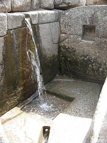
The uppermost fountain, Fountain 1 is
one of the most beautifully constructed fountains. Note the precise fitting of
the wall stones and the specially bored drain hole in the basin, and recall
that the medium employed was hard granite. This fountain, with its fine stone
work and providing first access to the water-- before it has been used by
anyone else-- is believed to have served the residence of the Emperor Pachacuti
himself.
Water discharged from the Emperor's private fountain flows under a two-meter
wide walkway to Fountain 2, here seen
from above (today this fountain is in an area of restricted access, hence the
awkward camera angle).
Below Fountain 2, the discharge canal has a side opening and the water flow is
split to go in two different directions. The
greater flow is directed to Fountain 3, the Sacred Fountain associated with the Temple of the Sun. Again,
note the superlative stone work, one of two pairs of niches (which may have
held small idols). This fountain is also distinguished by two L-shaped
decorative ridges flanking the water spout, which, in spite of the high sun
angle and lack of defining shadows, can be discerned in this image.
Water leaving Fountain 3 flows on to Fountain 4. However, the split in the water channel above Fountain
3 meant that this fountain could be turned off, with all the water bypassing
into Fountain 4, a unique feature in the fountain system. It should be noted
that according to Wright et al., it is not certain that this bypass
channel is of Inka origin.
The circular outlet to Fountain 4 was measured at 3.8 cm by Wright et
al., who calculated that this would limit water flow to the lower fountains
to no more than 100 l/m. The discharge from Fountain 4 drops into Fountain 5, which is wedged in the narrow
convergence of the bifurcated long stairway (the Stairway of the Fountains)
that ascends parallel to much of the fountain system.
Below Fountain 5, the Inka stone cutters, for no apparent practical reason, but
perhaps "just for nice", made the outflow channel split and then rejoin itself before the water
cascades into Fountain 6. In a second view of Fountain 6, note the coca leaf offerings left in the niche by
modern visitors.
From Fountain 6, the discharge crosses a walkway partly in an open channel and
partly underground to tumble into Fountain 7.
From Fountain 7 it is a short, straight, open run to Fountain 8.
Below Fountain 8 the connecting channel features a small step, perhaps for decorative purposes, before reaching Fountain 9.
From Fountain 9 the water passes in part through a channel hidden in a wall, to
then emerge and sweep around in an arc before falling into Fountain 10, which, as a consequence of
this channel maneuver, faces in a direction opposite that of the rest of the
fountains. Again, we may suspect the Inka hydraulic engineers were playing
with the water.
A short distance below Fountain 10 we find Fountain 11, and next comes Fountain 12.
The drainage canal from Fountain 12 passes under a wall to execute a sharp turn, then passes under another wall before allowing the water to cascade into Fountain 13. Note the stone rim on the
spout to Fountain 13, unique in the fountain series. At the time this photo was
taken, the drain to Fountain 13 was partially plugged with leaf debris, causing
some overflow of the basin.
Drainage from Fountain 13 passes under the fountain wall, through a short straight canal segment to disappear under a second
wall, beyond which it passes through a curved
channel before dropping into Fountain 14.
Needless to say, Fountain 14 is followed by Fountain 15. The discharge from this fountain passes under the
fountain wall to go a short distance prior to passing under the upper wall to Fountain 16.
Upon reaching the last fountain, the Inka engineers played a final trick in
bending the water to their will by creating a double right-angle turn in the channel just before the spout to Fountain 16.
Fountain 16, is called "the private fountain" by Wright et al.. Whereas
fountains 5 through 15 are all readily accessible from the Stairway of the
Fountains and evidently were intended for public use, access to Fountain 16
from the stairway is blocked by high
walls and this final fountain can only be entered from the Temple of the
Condor. Not only is access to the fountain restricted, but the walls
surrounding the fountain were originally higher, shielding this fountain from
public view. Even the double right-angle jog in the water canal can be
interpreted as an effort to enhance the user's privacy-- from outside the
fountain no one could look directly through the wall and see the fountain
spout inside.
From Fountain 1 to Fountain 16, the total drop, as measured by Wright et
al. is 26 m, in a horizontal run of 51 m.
The end of the line:
From Fountain 16, the last in the series, the surplus water is drained, in part
underground, into a channel that parallels a long
staircase leading towards the Dry Moat just outside the main wall to the
Urban Sector, and a main drainage for Machu Picchu. And so ends the famous
fountain series, the principal water supply for the Inkas of Machu Picchu.
Additional fountains at Machu Micchu:
During their investigations, Wright et al. re-discovered six other
fountains on a major Inka road leading down from Machu Picchu ruins to the
Urubamba River. At least two of these fountains were ceremonial fountains, and
this, along with the quality of the construction of the Inka road, suggest that
this was once and important entry to the city.
These final six fountains had a water supply independent of the main series.
Thus, Machu Picchu once had at least 22 water fountains, with two or more
water sources.
FYI: The background color used in this website is the html color officially
known as "Peru".
Photos on this website by Janie and Ric Finch, @copyrighted.